Each week the National Oceanic and Atmospheric Administration (NOAA) updates more than 1,000 electronic nautical charts, and those corrections are now easier to manage with the new Chart Tile Service.
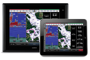
The NOAA electronic charts are used in recreational, fishing and light commercial or non-SOLAS vessels not subject to the ECDIS carriage requirements. These charts are accessed via chartplotters, tablets and mobile devices, as well as Web mapping applications on devices from companies such as Garmin, C-MAP, Navionics and Simrad-Navico.
Launched in December 2015, the NOAA Chart Tile Service provides standardized nautical chart tilesets for the public, eliminating the need for application developers to regularly transform NOAA files into tilesets for their applications.
The change should be transparent to users of these navigational charts, except the charts should be able to be quickly updated each week with hundreds of changes. That means users will have access to the correct versions in less time than before, according to NOAA.
The Chart Tile Service is comprised of 15 million individual tiles. Every week, the NOAA Office of Coast Survey identifies the tiles that have had an update, and sends those individual tiles.
These chart tiles are used by devices employing raster data, while ECDIS-level devices use vector-based charts. The raster tile charts are akin to photocopies, so if a change is made to one item on a chart, the entire section of the chart must be updated and re-issued.
Prior to the change, third-party commercial chart vendors had to create their own tiles from the NOAA raster navigational charts. Separating the NOAA updates into usable tiles was costly and time consuming, and resulted in inconsistent chart information among the sets of tiles from different vendors. As a result, chart providers typically rebuilt chart tiles only once or twice a year, which meant users did not have up-to-date charts.
“By subdividing raster charts into more manageable tiles that upload much faster, this new service will give navigation system developers greater ability to provide official corrections to NOAA’s nautical charts,” said John Nyberg, chief of Coast Survey’s Marine Chart Division.
In late spring 2016, NOAA expects to package tilesets for offline use, with all scales within a geographical region packaged together. These packages can be updated with only tiles that have changed since the last full package, dramatically reducing the size of the bandwidth required to keep a vessel’s chart suite up to date. NOAA’s chart updates can include data from full hydrographic surveys and vector shoreline data, as well as Notice to Mariners corrections for dangers to navigation.
On its website, NOAA cautions that digital nautical charts used in mobile applications do not meet the U.S. Coast Guard requirements for the mandatory carriage of nautical charts.