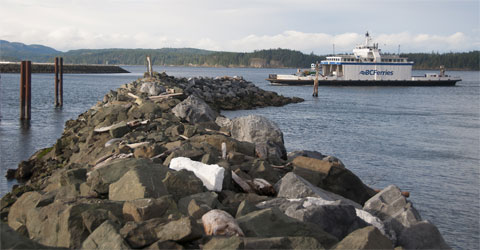
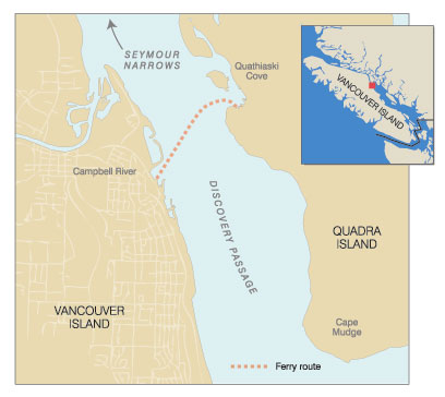
Running 14 miles from Cape Mudge on the southern tip of British Columbia’s Quadra Island to Chatham Point and the lower reaches of Johnstone Strait, Discovery Passage is known far and wide for the tidal bore at Seymour Narrows. An important link on the Inside Passage between the Lower 48 U.S. states and Alaska, the passage collects northbound vessel traffic wanting to make passage through Seymour Narrows on the slack tide to avoid currents that can reach 15 knots. The lower portion of the passage is less than a mile wide through most of the 10 miles from Seymour Narrows to the open waters of the Gulf of Georgia south of Cape Mudge. The east side of the passage is defined by Quadra Island with Vancouver Island and the town of Campbell River to the west.
School kids, usually about 120 per day, from grade six and up attend classes in Campbell River and a good number of people from Quadra work in Campbell River. Since about 1960 there has been a car ferry servicing the crossing between Campbell River and Quathiaski Cove on the Quadra side. The original little Quadra Queen has been replaced a number of times over the years to meet the growing population and so that today a larger ferry serves the route. Powell River Queen is 279 feet long with a 61-foot beam. The vessel has capacity for 392 passengers and 68 vehicles. All five of the vehicle lanes have high clearance for heavy trucks, and so the ferry has a deadweight capacity of about 500 tons. Some passengers will drive across Quadra Island to take another ferry to Cortes Island.
 |
|
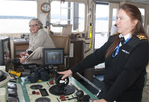
Capt. Esther Allen at the controls, joined by deck hand Julie Skeldon. |
Powell River Queen’s capacities meet the needs of Quadra Island for vehicular and foot traffic. Perhaps more importantly, the ferry’s propulsion system is ideal for the navigational needs of the crossing. There are four z-drive legs, one in each corner of the vessel. Each drive is powered by a 900-hp Caterpillar 3512B engine and is fitted with a four-blade 66-inch prop with 33.3-inch pitch. On the bridge, identical fore and aft stations negate the need to turn the ferry into the dock. Each station has two large joystick-type controls with integrated throttle and thrust direction for two z-drives. One joystick controls the forward drives and one the aft drives.
The four z-drives are put to the test on a regular basis. While tides can run up to 15 knots at Seymour Narrows, they can still flow at 4 to 5 knots at the ferry crossing just seven-and-a-half-miles away. The ferry landing at Quathiaski Cove on the Quadra Island side is well protected but once clear of the cove, the tide (especially a big north-flowing ebb) can require the ferry to run up into the current for some distance in such a manner that the boat’s heading will be 40° off its course over the ground. As they approach the shallower Vancouver Island terminal, the cross current can still be making over 3 knots. At the entrance to this terminal there are a pair of lighted dolphins set 400 feet apart.
|
Virginia Howe illustration |
|
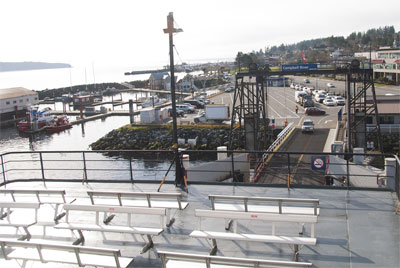
The ferry linking British Columbia’s Quadra Island with Vancouver Island crosses Discovery Passage, with Seymour Narrows just to the north. Storms and tides pose a challenge. |
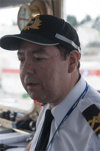
“We call them the goal posts,” explained Senior Master Capt. Shawn Fraser one March morning. We were watching from the bridge wing as Capt. Esther Allen, with mate Wayne Billy as co-navigator and lookout, conned the vessel through the goal posts and then to the landing. “For landings and departures the wheelhouse is designated a red zone with the bridge team left alone to concentrate on the task at hand without unnecessary distraction,” Fraser explained.
The Campbell River landing is much more exposed than the Quadra side. A rock breakwater provides protection for a marina adjacent to the landing, but it gives only minimal protection to the landing. When a big winter southeaster blows up from the long reach of the Straight of Georgia off Cape Mudge, another notorious piece of water, the swells can reach around the end of the breakwater to push at the ferry landing and the high sail-like sides of the ferry. Fraser pointed out a stretch of the breakwater that had been severely damaged in the previous winter’s storms.
“When we have to stop operating the ferry for weather,” Allen explained, “it is because of the exposed nature of this landing, not the crossing itself. This boat can handle most weather for the crossing.”
However, when a southeaster blows up Discovery Passage against a strong south-flowing flood tide, the result can be some very large seas with short intervals between the peaks. With the ferry traveling broadside to the seas and heavy trucks on board, some passengers can get a bit nervous that a loaded logging truck could tip or lose its load of logs. While the years have shown that this is not a real concern, the weather can do much to remind commuters that living, as they do, amongst a series of islands, keeps them in very real contact with the sea.
 |
|
Wayne Billy, mate on Powell River Queen, serves as co-navigator and lookout. He began his maritime career on salmon purse seiners and built up sea time aboard tugboats. |
The ferry is based in Quathiaski Cove so most of the crews also live on the island. Two of the mates, Brad Assu and Billy, are members of the We Wai Kai First Nation community at Cape Mudge and come with thousands of ancestral years of experience in the coastal tides. Starting their careers as commercial fishermen, they each went onto tugs to build up sea-time for the mate’s license before returning home and a job on the ferry. Allen grew up on Quadra Island and began her maritime career at 18 years of age as a cook on the tugs. She has now served 33 years with BC Ferries. Twenty years ago she became the ferry service’s first female master. She explains that being from the community that the ferry serves is a real asset for her and the deck crews. “Knowing which passenger is going to worry about possibly scratching their fancy new car if you make them park on the outside lane can help a lot,” Allen said.
With Seymour Narrows just to the north it is not uncommon to see heavy northbound vessel traffic just ahead of slack water in the Narrows. In summer there can be three huge Alaska-bound cruise ships coming in quick succession with similar southbound congestion just after the slack water. Fraser explained that when there are three southbound cruise ships and other traffic transiting the passage when the ferry is coming out of Quathiaski Cove, “we will sometimes have to hover there until the ships approaching our starboard side have gone past.”
In summer, the area is popular with recreational boaters and sports fishermen. A salmon fisherman, intent on playing a salmon that he has just hooked, is not likely to pay much heed to a ferry whistle. Year round, streams of Alaska-bound fish boats, Alaskan state ferries and tugs towing huge container barges are part of the routine that the ferry captains have to deal with. Add to that a steady stream of local traffic with tugs towing slow moving rafts of logs, and the bridge team makes sure not to ever let routine replace attention. Throw in a heavy fog to all of this and the radar with its AIS interface becomes an important piece of equipment. But the radar will not show a low floating log or deadhead. The B.C. coast is still a major logging area and driftwood is a constant threat. A big heavy log with 95 percent of its mass underwater can take out a z-drive if not spotted first.
 |
|
A car is ready to board Powell River Queen at the ferry’s Campbell River landing. Although there is a breakwater, this Vancouver Island landing is more exposed to the weather than the Quadra Island side. |
While the ferry is charged with maintaining a regular schedule that can see a round trip completed in an hour, speed in the crossing is not the most important consideration. Typically the engines are run at moderate RPM. “This gives adequate speed of a little over 10 knots and optimum fuel efficiency,” Allen explained. At the same time there remains plenty of reserve power to buck an especially strong tide or to make up lost time.
It is a treat to watch as Allen eases the double-ended ferry into the off-load ramp at either end of the run. Four indicators on the control console show the direction of thrust for each of the z-drives. But her hands on the joysticks tell her the direction and the thrust of the forward and aft drives. She works both for and aft thrusters in concert to ease the big boat into the slot and up under the raised off-load ramp. “It can take new operators, who are accustomed to twin-screw boats, a bit of time to get use to the fact that the pivot point is right in the middle of the vessel,” Allen explained. “When your bow is going to port the stern will be swinging in the opposite direction.”
With the wheelhouse equidistant from the bow and stern this puts the pivot point right under the operator’s feet. This is a distinct difference from the typical twin-screw boat with the pivot point well aft.
Once the vessel is snug in the slot, Allen presses a buzzer to tell the deck crew that she has quit maneuvering. They then make lines fast to secure the boat to the pier and lower the shore ramp. Even though she can clearly see the deck crew from the wheelhouse, Allen awaits their phone call to say that all is secure and to request permission to discharge the passengers. “We follow procedures as the landing is where most accidents happen on car ferries. But we have layers of safety on safety on safety,” she said.
For summer tourists, the crossing is a great little sightseeing trip. For the year-round residents, it is a chance to catch up on news from neighbors and other parts of the 20-mile-long island. For the 120 school kids who commute daily, it is a chance to socialize and let off a little energy. While many of the regulars are mariners themselves, the precision of the tidal navigation and precise landings are not their concern — they know that there are competent hands on the bridge.
As a service to customers, an electronic chart showing the status, course and speed of the Campbell River-Quadra Island ferry is maintained at: http://bcferries.applocation.net/routemaps/route21.html.