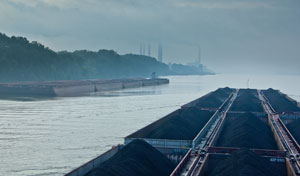
Since its introduction, radar has been an essential tool for maintaining a proper lookout for virtually all professional mariners. However, the way radar is used by river pilots varies dramatically from the way it is used by coastal and bluewater mariners. The most obvious difference between the two is the use of radar plotting.
Radar plotting is an utterly useless skill for river pilots since we almost never maintain a straight course or constant speed over an extended period of time. With a constantly curving channel and course, the principles of constant bearing and decreasing range have very little value and radar plotting becomes an exercise in futility. Even pilots of vessels having automatic radar plotting aids find that ARPA is non-effective in this environment.
This fact became a vexing issue for regulators as a result of the tragic accident at Big Bayou Canot in 1993. In response, federal regulations were enacted in an effort to prevent a recurrence of this kind of tragedy. Although initially it was an expensive lesson, in the longer term many of those regulatory changes have proven to be beneficial for the inland marine industry. We now have better training and higher licensing standards for pilots on the inland waterways. It also created more momentum for electronic charting of inland waters. However, one of the many challenges presented by these new regulations was the implementation of radar certification.
Even though radar has been in wide use since the ’60s, no one has been able to successfully explain exactly how river pilots use it. In other words, we knew what we were doing, but accident investigators and administrative judges certainly did not. In the absence of a recognized formal technique using radar for collision avoidance in inland waters, regulators started with somewhat of a “one size fits all” approach to radar certification. However, once they were confronted with the fact that traditional plotting would not work, they eventually decided on a “radar observer (rivers)” certification. This allowed some wiggle room for recognition of an alternative method of collision avoidance by providing for an equivalent to plotting without guidance as to what that method should be. As a result, actual course content for the radar observer (rivers) certification began to vary widely from one provider to the next. It has proven difficult to define a practical method that could be objectively taught, demonstrated and tested.
Another reason for this difficulty is that river navigation regularly requires vessels to meet within 600 feet or less of each other, so the actual risk of collision rarely can be determined more than three or four minutes, or at a range of one mile, before the collision occurs. Therefore, no method of calculating risk of collision can be complicated or time consuming because it then becomes a distraction in itself and contributes to the risk of collision. In other words, it needs to be simple, intuitive, effective and as passive as possible, while still meeting the requirements of Rule 7 of the ColRegs.
The U.S. Coast Guard has recognized a proposed method for inland mariners to use for collision avoidance. It involves using electronic bearing lines and variable range markers to create a “risk of collision” zone forward of your vessel and tow. (I am reluctant to refer to it as an “equivalent systematic observation” method only because Rule 7 uses this as a descriptive term instead of a proper name. Using it as a proper name implies that it is the only alternative). This method is fairly effective for use in the canals of the Intracoastal Waterway, but on Western rivers it can lead to some dangerously false assumptions.
The limitations of using this technique on rivers can be demonstrated by asking two simple questions:
1) Is it possible that a collision could occur without the other vessel ever having entered your “risk of collision” zone?
2) Is it possible for a safe passage to occur even when another vessel has remained in your “risk of collision” zone for a significant period of time?
Since the answers to these questions are both yes, then perhaps we should ask just how reliable is this method for accurately determining the risk of collision on rivers? The fact that another vessel is not in the danger zone does not mean there is no risk of collision. Likewise, just because another vessel is in the danger zone does not necessarily mean that there automatically is a risk of collision. Using this technique also has the inherent risk of obscuring buoys and small vessels on an otherwise clear area of the radar screen directly along the path of most approaches to the buoy line. Another limitation of this method is that it will not work in crossing situations or overtaking situations if you are the vessel being overtaken.
On close examination, the only two currently recognized radar methods cannot meet the specific requirements of Rule 7. Part A of the rule includes the phrase “means appropriate to the prevailing circumstances and conditions.” This clearly eliminates radar plotting because it is certainly not an appropriate means for the prevailing circumstances and conditions of river navigation. Part B includes “proper use shall be made of radar equipment,” which excludes plotting as well since it cannot be considered a “proper use” if it does not work. Part C says, “Assumptions shall not be made on the basis of scanty information, especially scanty radar information.” This excludes the “risk of collision” zone method described earlier, since a collision can occur without the other vessel ever having entered this zone. That means it is insufficient or scanty radar information. Part D does use the imperative “shall” in reference to romanettes (i) and (ii), but romanette (i) is dependent on an unchanging bearing, which once again does not apply with curving courses. Romanette (ii) just points out that even with a change of bearing there could still be a risk of collision, which actually points to the weakness of plotting once again. So the question then becomes what else is there?
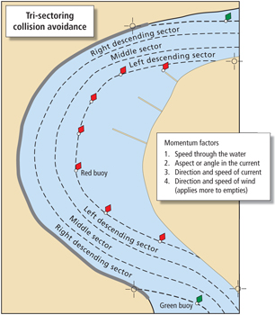
A better method is one that river pilots have been using informally and successfully for decades, but has never been officially recognized. I call it tri-sectoring. In this technique, all that is required is to determine by radar (or electronic chart system) whether a vessel is favoring the right descending edge of the channel, left descending edge of the channel or the middle of the channel, and treat each sector separately as equal thirds of the channel.
With river navigation, we normally use the shoreline or edges of the channel as objective reference points. That makes it more compatible with radio communication as it pertains to determining the manner and place of meeting, crossing and overtaking. Then the edges of the channel objectively determine the outer boundaries of your risk of collision zone. In effect, plotting is accomplished by close monitoring of each vessel’s proximity to the shoreline or buoy line, so the risk of collision is determined by whether each vessel maintains its bearing within its respective sector. (Monitoring the other vessel’s “present” bearing can be aided by enabling the echo trails function of your radar, but it should always be kept in mind that the bearing will be changing in response to their speed, aspect and the direction of the currents in the area.)
 |
|
Pat Rossi illustration/Capt. Gregory L. Smith |
Once passing or overtaking arrangements have been made by radio, each vessel takes opposite sections of these three sectors. This creates a buffer zone in the middle, thus allowing for some degree of flexibility on the part of both vessels. There is an identifiable risk of collision if any of the following occurs:
- It appears that the other vessel’s bearing will carry it into your sector.
- It appears that your bearing will carry you into the other vessel’s sector.
- It appears that the bearings of both vessels are moving into the middle sector.
For example, if you have agreed on a one-whistle meeting arrangement but on radar (or ECS) it appears that the descending vessel is in the sector closer to the left descending side of the channel without changing, there is a definite risk of collision and the passing arrangements need to be re-confirmed by radio before a close-quarters situation results.
In special circumstances, where the width of the channel and the size of the vessels allow for it, this technique provides for three vessels to meet or overtake at the same time, with one vessel taking the middle sector. However, all three vessels must be in agreement that the maneuver can be done safely. This also helps address the special circumstance when a deep-draft vessel is restricted to the middle sector, although the separation between vessels is reduced accordingly. Tri-sectoring provides a more objective means for determining whether there is safe meeting room in a particular area of the channel. Any area where the channel is so narrow that one vessel will take up all three of these sectors, or the vessel cannot avoid changing sectors due to the peculiar hydrodynamics, is an area where vessels cannot meet or overtake each other safely.
Even radar plotting in and of itself does not prevent collisions; it only helps you to recognize when a close-quarters situation is developing and/or imminent. That is exactly what tri-sectoring does, only faster. Tri-sectoring is intuitive and passive in the sense that experienced pilots can tell instantly by looking at the radar screen which sector another vessel is in. An equal spacing divider tool could be used to help make this determination quickly for training purposes or in cases where there is any doubt about which sector a vessel is in. This technique also provides a much more objective means for determining fault in a collision by looking at the sector of the channel where the collision occurred. In short, if you had a collision with another vessel in their agreed sector, then you better have a good explanation for why you were there. If a collision occurs in the middle sector of the channel, then both vessels will have to defend their actions under the rules.
This method meets the requirements of Rules 5 and 7 because it is “appropriate means,” it is “proper for the prevailing circumstances,” and it is based on solid and objective radar return information. It is more compatible with the ColRegs pertaining to narrow channels (Rule 9) and creates a self-imposed “traffic separation scheme” (Rule 10). It also carries the weight of being the “ordinary practice of seamen” (Rule 2). Another advantage is that this method adapts to ECS just as easily as radar. At some point in the future, once hydrographic survey information becomes more readily available, it may become feasible to have an electronic indicator on each vessel’s icon showing which sector the vessel is in, so that a more effective electronic collision warning could be used.
Having said all of that, I am firmly in the “whatever floats your boat” crowd, so I’m certainly not opposed to any technique that works as long as it meets the requirements of Rule 7 as it pertains to river navigation. Marine educators have been vigorously teaching the “approved” techniques simply because they were thought to be the only games in town. In their defense, it has at least had the effect of buying us some time until we could do a better job of explaining the method that we are already using. In effect, they bridged the regulatory gap for us, since something had to be done immediately.
As mentioned earlier, tri-sectoring is not really a new technique. It is basically the same technique river pilots have been using for many years; we have just done a very poor job of teaching it in a way that other people can understand. Tri-sectoring is simple, objective, intuitive, easily taught and easily enforced. It is the key to the past, present and future of collision avoidance in river navigation. With the exception of prayer, it is the most effective method for close-quarters collision avoidance known to man. It is what we should be teaching to river pilots and perhaps more to the point, it is also what we should be defining and defending in our courts.
Capt. Gregory L. Smith is a veteran of the inland marine industry with 40 years of experience training pilots. He is the author of the textbook River Navigation and is currently a heavy tow captain on the Lower Mississippi River. For information on obtaining his book, email glsmith6871@gmail.com.