Four ships outfitted with sensitive surveying equipment will gather data on vast swaths of ocean in and around Alaska this summer. The information will be used to update nautical charts for the region amid increased commercial ship traffic.
While charts are available for much of the region, Rear Adm. Gerd Glang, director of the National Oceanic and Atmospheric Administration (NOAA) Office of Coast Survey, said the existing information “is not sufficient for safe navigation.”
“What we worry about is not so much the accuracy of the information. It is, what is the scale of the charts and how current is the information?” he said, adding that some existing survey data dates back hundreds of years.
“As we do new surveys, we are improving the accuracy of the information simply because the tools we use nowadays are much more accurate than the tools that were available 100 to 150 years ago,” Glang continued.
NOAA is overseeing surveying for the Arctic Marine Corridor Project with assistance from the U.S. Coast Guard. The joint project has been under way since 2011.
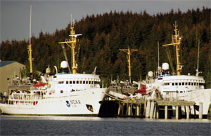
This summer, the NOAA ships Rainier and Fairweather will perform surveying along with a privately owned contractor vessel. The U.S. Coast Guard cutter Healy will continue collecting multibeam echo sounder depth data used to verify information on existing charts. Healy and other Coast Guard vessels have gathered similar data over the past several years.
The vessels will cover nearly 12,000 nautical miles, including a 3,200-mile north-south route from Unimak Island in the Aleutian Islands through the Bering Sea to the Chukchi Sea proposed in the USCG Port Access Route Study.
The ships also will gather data around uncharted sections of Kotzebue Sound and areas near Point Hope and Port Clarence in Alaska. Rainier and Fairweather left Kodiak, Alaska, on June 8 to begin the survey project.
The area from Unimak to the Chukchi Sea is considered a top priority given possible interest as a major shipping route, according to Cmdr. James Houck, waterways management branch chief for U.S. Coast Guard District 17 in Alaska.
“These 3,200 square miles have been deemed a top priority and most of it will be surveyed this summer by NOAA ships Rainier and Fairweather,” Houck said. “Charting improvements from these joint efforts will replace soundings, currently on charts, recorded by Captain Cook in the late 1770s.”
In addition to the Arctic surveying projects, the NOAA ships’ 2015 non-Arctic Alaskan survey projects include Chatham Strait, Shumagin Islands, Kodiak and west Prince of Wales Island, the agency said in a news release.
 |
|
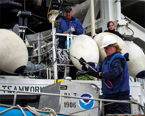
Rainier’s chief bosun, Jim Kruger, front, and crewmates Jason Kinyon and Lindsey Houska get equipment ready for the season’s first project in Kotzebue Sound. |
|
Courtesy NOAA |
Coast Guard data shows a marked increase in commercial shipping activity off Alaska’s western coast. In 2012, roughly 480 vessels transited the Bering Strait, more than double the number from 2008, according to the Coast Guard. That number fell to 340 in 2014.
However, with cruise travel and oil and gas activity expected to increase in the coming years, authorities expect Arctic waters will only get busier.
“With trillions of dollars in oil reserves estimated to be above the Bering Strait, I think it’s a safe assumption that traffic will increase, just based on the economic drivers,” Houck said.
Federal authorities review AIS tracks to determine where the ships traveling in the region are headed, which helps officials prioritize surveying efforts, Glang said. The agency also responds to requests from commercial operators for better charts for a particular area.
Surveys around Port Clarence, for instance, are driven by interest in creating a new deepwater port on the Bering Strait. Glang acknowledges not everyone agrees with the current priorities.
In 2011, NOAA identified the need for 14 new charts covering waters off Alaska. Since then, three new charts have been released showing northern sections of the Bering Strait, approaches to Kotzebue and approaches to the Delong Mountain Terminal facility linked with the Red Dog Mine. Glang said the pace of current data gathering allows roughly one new chart to be completed per year.
U.S. authorities have been “chipping away” at surveying coastal Alaska since at least the 1960s. Glang said the current focus in northern and western Alaska is something of a natural progression.
“We would have ended up in northern Alaska anyway,” he said, “because that is where the blank spots are.”